From Dry Dock to Deep Dive: Bedrock's First Year Under the Waves
This is part 1 of 4 of a series of weekly blog posts, where we will present the outcomes of our 2023 ocean field tests, detailing the operational procedures, data processing methodologies, and findings.
Believe it or not, a year ago today, Bedrock Ocean Exploration's autonomous underwater vehicles (AUVs) had never been in the ocean.
This isn't a huge surprise, considering that designing, building, and preparing your own fleet of AUVs for ocean deployment isn’t exactly trivial. Plus, Bedrock’s AUVs aren't your average underwater drones: they’re lightweight, portable, eco-friendly, whisper-quiet, and packed with the latest in oceanographic tech. Think of them as self-driving cars of the sea, but cooler because they can dive deep and come back with treasure troves of data without bothering a single dolphin or whale! This post is the first in a series detailing the significant strides we've made since those initial days, starting with our very first field tests in Monterey Bay.
In March of 2023, Bedrock completed our first-ever ocean deployment. The primary aim of our first day in the ocean was straightforward: to validate the operational capabilities of our AUVs in marine settings and ensure the reliability of the collected data. We ventured into the sea not with the expectation of groundbreaking discoveries, but with the hope of learning, improving, and contributing to the broader narrative of ocean science. And we did. After successfully gathering bathymetric, backscatter, side-scan, and magnetometer data, we made our first small public contribution to the vast oceanic knowledge base – check out the resulting data and analysis here!
Following the initial test, a second field operation focused on mapping a known outfall pipe. This exercise provided practical experience in applying our technology to specific targets and contributed to validating our system's effectiveness in real-world conditions. By locating the pipe and mapping the surrounding seafloor, we contributed valuable data to the scientific community, helping to correct discrepancies in existing charts and improve our understanding of underwater infrastructure impacts. Processed data and detailed analysis are freely and publicly available here.
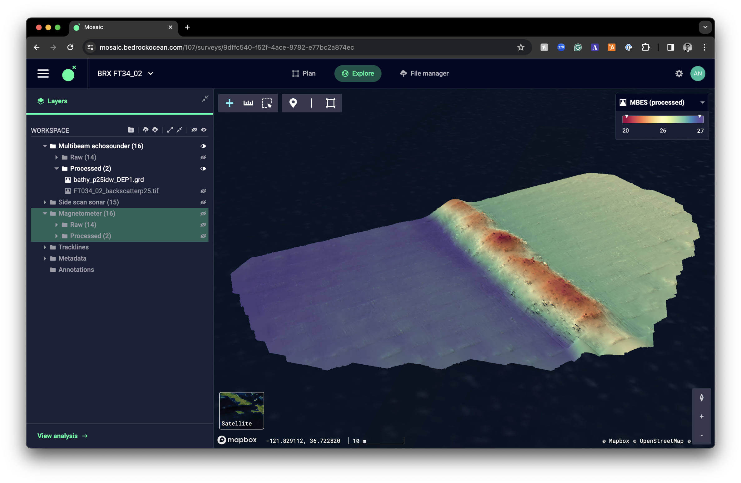
Fig. 1 Processed bathymetric map of the outfall pipe in Bedrock’s mosaic platform.
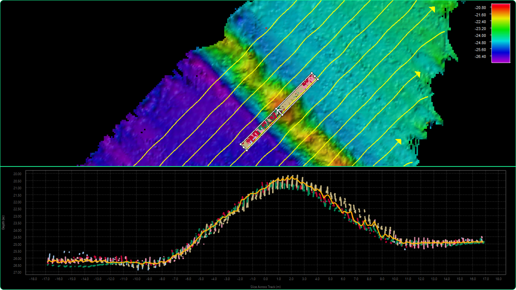
Fig. 2 Bathymetric map data (top) and extracted 2D profile (bottom). This 2D profile of the bathymetric data over survey pipe area shows the pipe 4 meters proud of the seafloor and the difference in seafloor depth on either side of the pipe, indicating this outfall pipe may act as a barrier for alongshore sediment transport.
In our next post, we will delve into our approach to system characterization and calibration. These posts are intended to offer a transparent view of our early-stage explorations, underscoring the progress we are making toward contributing to the field of oceanographic exploration.
Stay tuned for detailed accounts of each field test, as we continue to assess, refine, and enhance our approach to underwater exploration and data collection.
Permit #: MBNMS-2022-023-A1