Bedrock Demonstrates Key Capabilities at U.S. Navy’s Advanced Naval Technology Exercise
Bedrock recently had the honor of participating in the U.S. Navy’s Advanced Naval Technology Exercise (ANTX) as part of their Coastal Trident Program. This afforded Bedrock the opportunity to conduct survey operations off the coast of San Diego, California over areas with a variety of targets of interest using its latest generation of vehicles recently debuted in its Proof of Technology Program. Data collected in San Diego will not only be shared with participants in ANTX, but also with participants in Bedrock’s Proof of Technology Program, to showcase how our system is well suited to meet the critical survey needs of industry and government partners. .
On August 8, Bedrock demonstrated its key capabilities to end users and partners including Mine Countermeasures Group (MCM), Naval Sea Systems Command (NAVSEA), SEARCH, Avangrid, Norbit and Nortek. Stakeholders were given the opportunity to meet the team, see the vehicles and witness near real-time data acquisition firsthand.
Across nearly two weeks of surveying, the team successfully mapped targets including an outfall pipe, a sunken plane, barge and tugboat, a piling and various objects placed on the seafloor by the Navy as part of the ANTX event. Datasets collected include side-scan sonar (SSS), multibeam (MBES) bathymetry, backscatter, sub-bottom profiler (SBP) and magnetometer (Mag) data. Below are various teasers of data collected throughout the survey operations.
MBES bathymetry view of submerged pipe infrastructure with minimal processing mapped using Bedrock’s custom OEM MBES-42 WBMS from Norbit aboard a Bedrock AUV.
MBES backscatter imagery close up of the same pipe structure as above bathymetry image highlighting perturbation of seafloor sediments associated with outflow regions of the pipe.
MBES 3D bathymetric view (top) at 2X vertical exaggeration showing a sunken barge in approximately 40m of water after correction to MLLW. The barge is approximately 37m long and 7m wide. The seafloor shows some indication of scour to the northeast of the barge, and a profile extracted over the barge (bottom, 5x vertical exaggeration) highlights the presence of a seafloor slope to the southwest.
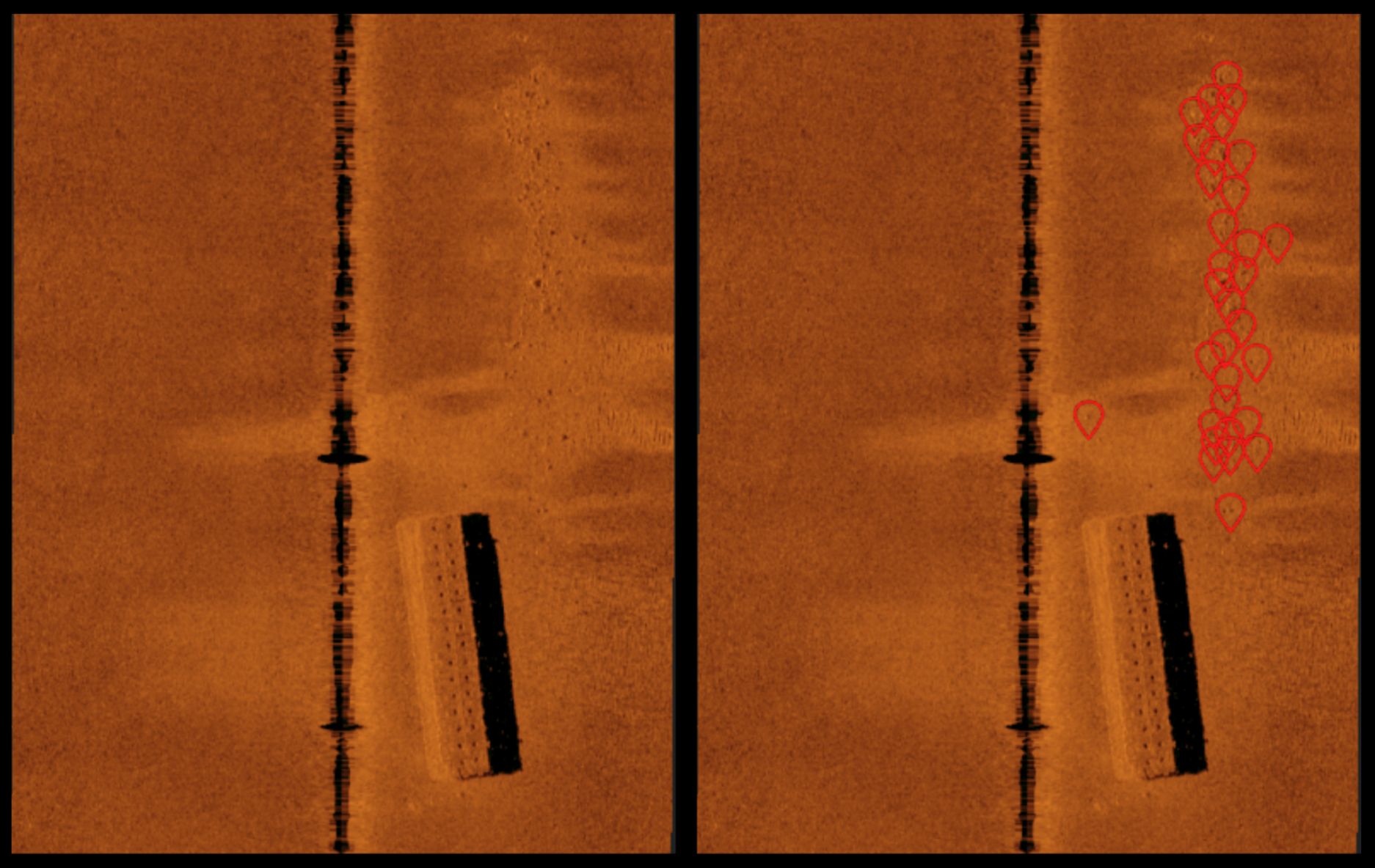
Side-scan sonar imagery taken from a single line pass over the same sunken barge after light processing (AGC and slant range correction). The region just north of the barge shows evidence of scour, with numerous boulders. On the left we show the barge and scour without interpretation and on the right after an AI boulder detection tool is run over the dataset.
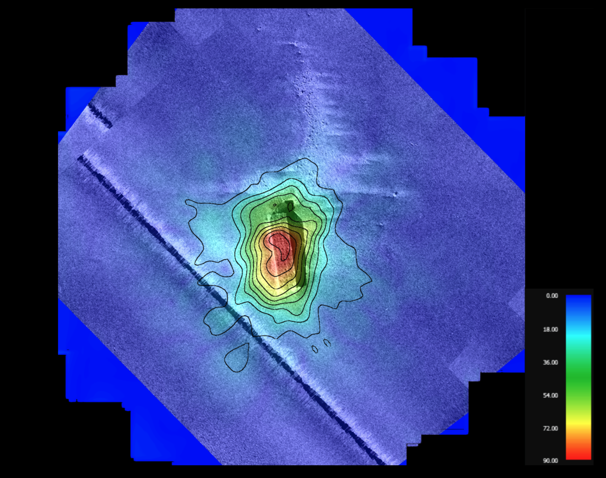
Overlay of MBES bathymetry, SSS imagery, and magnetometer analytic signal grid all collected over the sunken barge as shown above. Layering the magnetic data onto this dataset highlights that the scoured boulder field in the north is unlikely to contain ferrous anthropogenic debris. This image highlights how combining datasets facilitates a richer understanding of the seafloor and targets.
The demo day also gave the team the opportunity to debut Bedrock’s proprietary onboard data reports. Whereas traditional manned survey vessels have people manually monitoring raw data acquisition live onboard, Bedrock leverages automation and algorithms onboard its vehicles to lightly process data and transmit it to remote team members after each survey line. This enables near real-time data analysis and rapid response to what is discovered in the field.
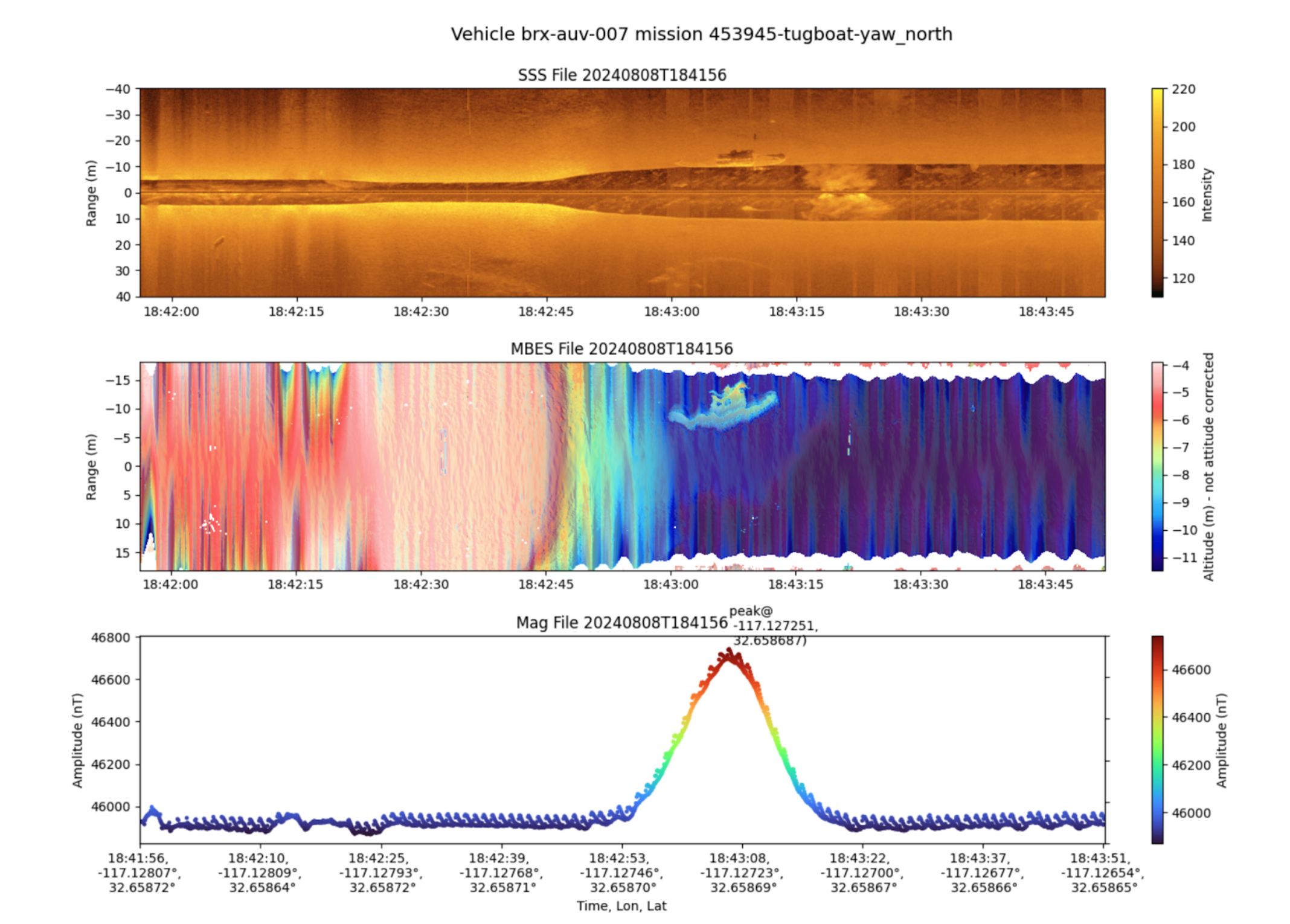
Sample image of Bedrock’s proprietary onboard data report, which the AUV automatically generates at the end of every survey line. Image shows side-scan sonar imagery (top), multibeam bathymetry prior to depth and attitude correction (middle), and magnetic total field (bottom) for a single AUV survey line. Here the AUV surveys a sunken tug boat, identifiable in all three datasets.
The Bedrock team is working hard to process data collected in San Diego and formalize its findings to be shared with both participants from ANTX as well as its Proof of Technology Program. Once ready, findings will be presented in a webinar to relevant stakeholders. If you are interested in engaging with Bedrock, there is still time to become a participant in the Proof of Technology Program. Reach out to sales@bedrock.com to learn more.


